Bruce Campbell has started a debate about lost watercourses through Harpenden. Below, Les Casey and John Wassell comment on this proposition. Others are welcome to join the debate.
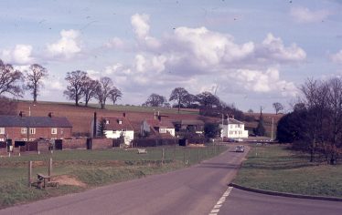
Kinsbourne Green – The Common slopes gently down to the A1081
Harpenden residents will be familiar with the name Kinsbourne and the associated area lying to the north of our town. ‘Bourne’ is an old English word for a river in the chalk lands which flowed in winter time but dried out during summer months. The word Kinsbourne suggests therefore the existence somewhere of a river Kin. It does not appear on any Ordnance Survey map but its course or what remains of it can be traced quite readily from its source to its junction with the Colne river and thence eventually to the Thames. The depth and the width of the remnants of the course suggest a river with a very substantial flow at least during periods of peak rainfall. We can only surmise when the Kin was an active healthy river. What we do know is that in the Kinsbourne Green area the water table was very much higher historically than it is today. This level of water table in turn gave rise to a very active spring line which in turn gave rise to the head waters of the river Kin. There are several names whose provenance suggests that this is so. An access road at Annables is named Spring Road and there exist two large copses – one is named Long Spring and the other Kinsbourne Spring. The reason they are wooded is that they were considered by the land owners as being too wet to plough. They are situated to the south and east and close to the property of White Walls.
The Kin then sprang to life in this area and followed a course north east for a distance of about half a kilometre until it met what is now the roadway of the A1081. At this junction it turned abruptly south east towards Harpenden. A well defined remnant of the course can be seen on the west side of the A1081 close to the access to the Thrales End Lane. Here a tree line obscures a dry river course some two metres deep and four metres wide and some one hundred metres long. The course followed through Harpenden feeding the ponds at Southdown and thence through Southdown itself to Cross Farm, West End Farm and Nomansland. Parts of the course are clearly defined running parallel to the road until it reaches the present B651. It crosses this and deviates to the east and south until it reaches the village of Sandridge and thence to the gravel pits near the Beech Farm and onto the river Colne.
There seems little doubt that at one time it was a very substantial river indeed. Why does it not flow today? The reason of course is the need for water from an ever burgeoning population and the ever increasing demands on the aquifers for its supply with the consequent lowering of the water table and the demise of the spring lines at Kinsbourne Green.
Les Casey, the Society’s curator and former teacher of geography and geology, replies:
In the later stages of the Ice Age the front face of the great ice-sheet which covered most of ‘Britain’ was piled up against the northern scarp face of the chalk range which would form the Chiltern Hills. At the foot or ‘sole’ of the ice-sheet fragments of the many rocks over which the ice had passed were embedded as sands, silts and gravels in the base of the ice.
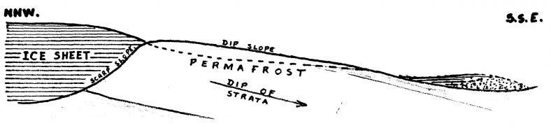
The Ice-sheet on the NNW face of the Chiltern Hills
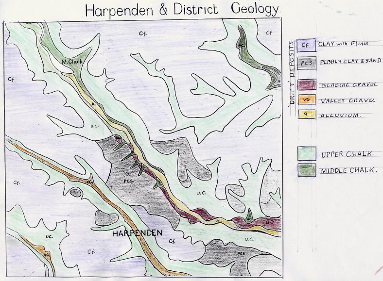
As the climate changed and the ice-sheet began to thaw, melt-water percolated through crevasses down to the sole, washing out those embedded materials. Accumulated melt-water found a dip in the crest of the chalk scarp and spilled over to flow down the dip-slope to form a valley the floor of which became covered with deposits of the glacial gravels. See the geological map below.
In the ‘Pluvial Period’ which followed, heavier rainfalls produced streams flowing over the dip-slope of the chalk, perhaps where remaining perma-frost first prevented percolation of water into the chalk. Then when the permafrost had melted, rain did percolate into the permeable chalk until saturation raised the ‘water-table’ and surface streams continued to flow creating the new valleys – headwaters of the Ver, Gade etc and valley which now passes through Harpenden.
Formation of the Lea Valley
In the glacial overflow channel, normal river erosion deepened the valley, cutting down through the glacial gravel deposits, reducing them to marginal terraces on the spurs between the new tributory valleys of what is now the Upper Lea Valley.
As the climate became gradually drier, the level of saturation (water-table) became reduced and the dip-slope valleys became ‘dry valleys’ with only intermittent streams during rainstorms. The Lea Valley, having been cut deeper, still reaches the water-table and the river still flows (though now supplemented by the discharge of treated water from Luton water-treatment works).
Watershed
White Walls at Kinsbourne Green is perched on the 500 foot watershed between the Ver Valley and the Harpenden dry valley. The ridge is covered by ‘drift’ deposits of ‘clay-with-flints’ as shown in the geological survey map. These may account for the wet patches which may appear around Kinsbourne Green, but the contours on the 1/25,000 OS map give little indication of tributory channels down to the Harpenden valley except for one near the county boundary just below Gibraltar Farm on the A1081.
The ditch which lies parallel with the A1081 near the Ridgewood Drive corner ditch appears to be a line of old gravel workings, composed of valley gravel, not ‘glacial’ gravel.
The Harpenden dry valley (the Anglo-Saxon Herpedene) does extend through ‘the village’, where cottages could draw water from their wells, and on through Southdown, Nomansland, Oaklands and Smallford to join the River Colne.
John Wassell, the Society’s Newsletter editor, adds some comments:
Maps
There is no reasonably accurate old map showing a river along the valley. Dury & Andrews map of 1766 is the first that shows demonstrably accurate mapping of physical features down to ponds and individual buildings and it shows no river or stream in the Kinsbourne Green area.
‘Kinsbourne’
Kinsbourne is the relatively modern version of the name. The question is whether the second part means ‘bourne’.
The oldest record dates from 1201 and is ‘kenesberne’. The writers of the Society’s booklets on Harpenden’s history considered this to mean the burial place of Cyne (no K in Anglo-Saxon/old English, so pronounced ‘Kyne’ and usually spelt with a ‘k’ as in the latin usage, eg Claudius, Cato). The phonetic renderings/misrenderings of local names are a constant source of confusion to researchers. I have found the following variants from various sources:
- 1201 kenesberne
- 1225 cunesburne
- 1291 kenesborne (name of the manor)
- C1350 kynnesberne (family name of local landowner –evidently from the place)
- 1650 kingsbarn
- 1695 kinsburn (John Oliver’s map)
- 1766 kingsburn (Dury & Andrews map)
- 1821 kennesbourn (Bryant’s map)
- 1842 ‘kennesbarn or kinsman green’ (Harpenden Tithe Award map)
I could not find a word like ‘bourn’ or ‘bearn’ etc meaning burial in an Anglo-Saxon Dictionary. Personally I think the origin may be from ‘cyne’ and ‘berearn’ – both found in the dictionary I used. Cyne (Kyne) being here a prefix meaning ‘king’ or ‘kingly’ and berearn = barn/barns, so meaning Cyne’s Barn or the King’s Barn. As the original name is at least 1,100 years old no doubt others may have different opinions!
The ‘Herpedine’
This is the name given to the boundary of Wheathampstead in a charter of 1060 in the vicinity of Kinsbourne Green. It refers to that part of the valley from just south of Gibraltar Farm to Thrales End Lane where the parish and county boundaries ran (and still run) along the road from St Albans to Luton. It is apparently a corruption of the Anglo Saxon words for a military road running through a dene or valley. ‘Dine’ or dene (from ‘denu’) was specifically used to denote a narrow dry valley and is discussed in detail in ‘The Origins of Hertfordshire’ Tom Williamson, pp 171-173, where the herpedine itself is discussed.
‘Spring’
Care is needed here as the term is a regional dialect word for a small coppiced area of woodland. The 1840’s Tithe Awards for Harpenden parish show nearly 40 examples of this name applied to these small wooded areas – as far as I am aware none of them is also a water source.
The Old Cock Pond and the Southdown Ponds
I agree that some water would at times have run along sections the valley from ground sources – the most obvious being the water source on the east side of Harpenden High Street opposite Church Green. This was probably the reason for Harpenden’s foundation. It later fed two breweries and formed a pond until modern times and still affects properties along the High Street.
The run-off has been channelled to the ‘Southdown Ponds’. I understand that water that used to run beyond these excavations ran into a sink-hole opposite Crabtree Lane and reappeared near South Mimms.
All the above are of course open to challenge, as all good research should be. Far too much ‘history’ is simply repetition of ‘facts’.
Geology of Ver, Harpenden and Lea Valleys
Comments about this page
Are the contributors aware of speculation that Kinsbourne is possibly the basis for the fictional Longbourn of Jane Austen’s Pride & Prejudice, with Harpenden being the fictional town of Meryton? Here’s the link to what seems like a genuine, well-researched piece – https://www.jasna.org/persuasions/printed/number27/smith.pdf.
Ed – Yes, we were aware of Ken Smith’s paper, with its interesting suggestions, though not all fit with houses at the sites mentioned (eg Limbrick Hall was not so-named until the 1870s, having previously just been a farm, like Bamville). But there are other interpretations, in particular from John Wassell, our Newsletter Editor :
“Some years ago I saw Ken Smith’s paper and wondered if Jane Austen got her mileages from a map of Hertfordshire. I thought that the Dury & Andrews map of Hertfordshire, first published in 1766, would have been available to her. This shows milestones with mileages on the various turnpike roads in the County. The London road to St Albans divides there and roads go to Luton (through Harpenden) and to Dunstable (Watling Street). The 24 mile marker on Watling Street is close to Redbournbury and the 24 mile marker on the Luton Road through Harpenden is just north of Ayres End Lane, which leads to ‘Aiery End’ according to the map. This location is a couple of miles south of the then village of Harpenden. Some of these markers still exist in the form of 19th century cast iron markers (listed grade2 monuments!).
The more likely candidate is the Watling Street marker – perhaps Redbournbury = Longbourne (with Beaumont Hall as Lucas Lodge?) I suspect that Jane’s names are imaginary even if based upon real places in this part of Hertfordshire.
The markers have been moved northward since then due to road improvements – for example the Luton Road 24 mile marker now sits opposite Beesonend Lane, a few hundred yards north of it’s location in JA’s time.
JW”
There are numerous other theories as to the location of Longbourne, Meryton etc online.
About subsurface water resurfacing at South Mymms:
Before the Anglian glaciation, the proto-Thames flowed up the Colne valley, through the Hatfield area and along the middle Lea valley in the Hertford / Ware area. Despite having been blocked, there is still a general flow of water through the chalk along the old course, although not an actual subterranean river.
The water that disappears at Water End near North Mymms joins this system, and re-emerges mostly around the springs between Hertford and Ware that feed the New River.
This was found by tracing the pollution plume from an old chemical factory in Sandridge, in the lower Harpenden dry valley, it was found that groundwater here also flows under Hatfield towards Hertford.
In this area of Hertfordshire, we find that surface and groundwater can flow in different directions.
I am pleased to see that the saga about the River Kin continues to raise debate. Firstly, I must admit to neither being a historian nor even an amateur one. However, I am well qualified to observe, describe and interpret landscapes having done so in many parts of the world for much of my working life. So in answer to the contribution from Mr Cox we need perhaps to cover the ground, so to speak, once again. The area of Kinsbourne Green was and indeed still is an area of intense periodic wetness. The key causal agent for this condition lies with the presence of a deep deposit of clay contained in a cleft within the stratas of chalk. Clays are characterised by having a very high water holding capacity and when fully saturated excess water is released under certain conditions in the form of springs. These in turn, if sufficiently active, give rise to the formation of bournes, streams or rivers. From the note by Mr Cox on the question of springs, it might appear that he is unfamiliar with the presence beneath our feet of this expansive area of clay ‘slip’ which extends in length over a distance of some five miles with Kinsbourne Green at its mid point, and the importance of it as a reservoir for winter rains.
The writer has lived at Kinsbourne Green for some fifty years. The presence of spring water at some time during the winter months can invariably be noted. The location of the springs is indicated by the prolonged presence of standing surface water which often results in significant damage to winter sown crops in adjacent arable land. The presence of springs can also be noted from the presence of ponds and lakes acting as reservoirs of spring water. The spring activity today is much reduced compared to yesteryear by the marked draw down of the aquifer over the past years. Our forbears however certainly noted spring activity to the extent of demarcating, naming and mapping their position. Thus we find Jenny Spring, Eight Acre Spring, Long Spring, Spring Field, Penny Pond, Watery Lane, Spring Road et al. I cannot speak for the rest of the county but a spring at Kinsbourne Green does mean a spring, a water source as defined by any geological dictionary and has no other connotation. Historically, these springs were sufficiently active to form substantial flows of surface water during winter months; the principal flows were named the Kin and the Bray. The depressions in the land surfaces which these flows created and followed are clearly visible today and sections of them often flood after periods of heavy rainfall.
There now remains the issue of the provenance of the various spinneys and woodlands at Kinsbourne Green. These are self generated, lying proud of the prime agricultural land surrounding them. One such spinney is composed of at least twelve species and for the sake of completeness is listed as follows: Oak, Cherry, Holly, Ash, Hawthorne, Laurel, Blackthorn, Beech, Sycamore, Hazel, Elder and Wych Elm. Neither in shape nor form does this and other similar woodland resemble the remnants of a commercially coppiced woodland, marvellous examples of which are still to be found at Marshalls Heath, Hertwood Forest, Ashridge Estate and elsewhere.
There can be no doubt that the woodland at Kinsbourne Green is self generated on areas of land subject to intense and prolonged water logging and too wet to plough and even too wet to establish permanent pasture. Their presence over the years must also have contributed, by transpiration from depth, to the localised amelioration of the high water table and a reduction in flow from the springs contained within their boundaries.
Finally I concur, without qualification, the need to be rigorous in the documentation of the natural history of the areas we live in. Hence, the reason why the contribution from Mr Cox has been replied to and its contents challenged.
See also my page about The Slip.
That Kinsbourne in its various historical written forms has the original meaning of the “Cynesbeorg”, the burial place of the king, is discerned by toponymists (place name experts) by working backwards using the strict rules of historical linguistics from the written versions in Middle English back to Old English. The ways in which names developed after that time through Middle English into early modern English too are taken into account. There are known well-defined processes that give rise to both vowel and consonant changes and shifts and changes in grammatical aspect with time that allow linguistic experts to do this. Grammatically the -s- denotes a genetive (possession) but this is not of a stream but a king in this case. This process isn’t without some criticism and indeed had there have been proper topographical and geological evidence for a spring and a stream perhaps some revision might have been in order.
However, the Geology of the dry valley at Harpenden is clear-cut as being glacial in origin. The gravels on the common are outwash from the glacier and they formed part of the river terraces of the proto-thames river system and its temporary and more permanent tributaries.
The work of Phil Gibbard and the Quaternary Research group at Cambridge has over the last two decades elucidated a lot of the complex geology of formation and erosion of these terrace deposits. They have shown too that the the original course of the Thames was through the vale of St Albans but when dammed by an eastern tongue of the ice of the Anglian Glaciation at Hatfield (see Tony Rook History of Hertfordshire for a good diagram) it diverted to its present course. It also gave rise to a pro glacial lake at Hatfield which in turn caused pooling of water back up the Lea valley to Wheathampstead and possibly at Nomansland. The gravels show that the ice and drainage system brought rocks from NW England and from Wales So it was a very extensive river system.
The word “Spring” is indeed not to be confused with the woodland term which is specific to a coppiced wood for producing poles. New wood “springs” from the coppiced stools of hazel or hornbeam. Stocking Spring in Wheathampstead combines two coppicing terms. Stocks, stockings or stubbings refer to the stumps. In fact most of the remaining small woodland in the area show signs of ancient coppice management.
Geologically the position of Kinsbourne isn’t propitious for a spring. In our district a spring line can be found where the chalk overlays the “chalk rock” which is a harder less porous layer that runs the length of the base of the Lea valley from Batford to Wheathampstead on both sides and forms part of the base on which the old Dunstable to WGC was built between Leasey Bridge and Batford. It is the origin of the springs that were at Batford and the “Causewell” at Castle farm at Wheathampstead. Castle in this case being a folk etymology of the original word Causewell which is from a Norman French word “Causse” or limestone. It gave rise to the false impression that what turned out to be a natural gravel formation might have been the Motte of a Norman Castle.
It is essential to be very rigorous in local history research to avoid creation or perpetuation of myths due to lack of specific knowledge. At the same time it must be said that if the experts explained better how they arrived at their conclusions it would help non expert local historians fall into the many traps that seem to await them when they bravely venture out into the territory.
Ed – thanks for the very interesting topographical and etymological information.
I have read with interest the comments made about the existence and provenance of the River Kin. The Kin is not of glacial origin but its provenance is a large clay deposit which resides between the beds of chalk. This cleft or slip of clay is of substantial depth and width and originates south of Harpenden and trends north terminating near the village of Slip End in Bedfordshire.
Historically within this slip there was a very high water-table. During winter, its level was frequently topped up to levels which allowed substantial surface flows from several springs in the Kinsbourne area and perhaps elsewhere. The channels of this escaping water may not now be discernible at a mapping scale of 1:25000 but on the ground they are still clearly visible and at certain points along them periodic flooding continues to occur. There are three main channels which fed the Kin in this area. The first starts in the proximity of the entrance to Chamberlaines at its junction with Annables Lane and continues North-eastwards across Kinsbourne Green Lane (at which point it still periodically floods) eventually joining the A1081. The second starts at the copse in the proximity to the Whitewalls trends north-eastwards still feeding two large lakes, then crossing Kennels Lane (at a point which still floods periodically) and thence to the A1081. The third main water channel is to be found in the proximity of Lady Bray Farm again flowing north-east and joining the A1081 south of Gibraltar Farm. All these remnant water courses are clearly visible to the eye and would have carried substantial flows of run-off water from the presence of a very high water table in the clay slip. As noted by Mr Casey, there is evidence of substantial gravel workings along the entire length of the river Kin and of course the presence of gravel and the presence of a river bed are strongly and positively correlated.
Ed: Our curator, Les Casey, has assembled a large collection of photographs of the Dry Valley (of the Harp or Kin) from Zouches Farm near Blow Down, Dunstable, to Colney Heath. Your observations add to the understanding of the landscape.
Many years ago I was told that the “river” still ran under the Lower High Street, and that the horse chestnut tree next to the Harpenden Arms comes into leaf many weeks before any other, because its roots dip into the river.
There must be scope here for a discussion on the alleged drying up of the nearby River Ver watercourse in Verulamium to allow the Saint to cross it on the way to his execution. Was this legend or geological possibility?
Add a comment about this page