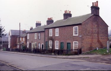
“Uxbridge Terrace”, 1 – 8 Amenbury Lane cottages
This list started from a transcription by Barbara Cotton from research records kept by her late husband Simon Cotton in the 1980s, with reference to “The Place-Names of Hertfordshire (PNH) & Workers Educational Association/History Publishing Society booklets 1973-91 (HPH)”. Current road names are highlighted in bold.
There is scope for additions and corrections to this page! Please add information in Comments -or contact us with information which can be incorporated into the list in due course. *Roads added from Comments received are marked with an asterisk*
The choice of road names by developers and approved by the local planning authority is not always explained – but it is interesting to know what lies behind the choices made.
ALDWICK ROAD: Aldewyk 1432 PNH
ALZEY GARDENS: Alzey is Harpenden’s twin town in Rheinhessen, Germany
AMENBURY LANE: Also known as Freeman’s Lane: ‘there used to be at the top of the lane a man named Freeman who was clerk at the church before Mr Griffkins. He said “Amen” (loudly/before anyone else) in church, and some people called it Freeman’s Lane and some Amen Lane’. Now it has become Amenbury Lane. It was also known as Bruton’s Lane and Hay Lane. Shown on the plan for the sale of the St Nicholas Estate 1897 as Park Lane; but on the the sale particulars (Holyoak) 1886, as Crouch Lane, otherwise Amenbury Lane. (vide NL 45) *See Comment below dated 10/12/2013
AMBROSE LANE: Henry Ambroys 1307 PNH
AYRES END: Thomas Ayre 16th c 1597 Aries End in 1705 PNH
Batchelor’s Row, Church Green
*BACHELORS/BATCHELORS ROW: Also known as Church Row. Road fronting on to Church Green (now M&S + flats above). *See Comment below dated 05/08/2014
*BACK LANE: There are records of two Back Lanes over a mile apart. One leading to Further Bruton’s field, *see Comment 10/12/2013, and one at Coldharbour (Census of 1851 to 1881), *see Comment 27/01/2015. Exact locations not known.
*BALFOUR COURT: Named after Balfour Beatty the developer, NOT the politician.*See Comment below dated 17/10/2020
BAMVILLE WOOD: Richard de Bamfeld 1272 PNH
*BARTON CLOSE: See also Wroxham Way, Oulton Rise, Hickling Way, Waveney Road, Martham Court. All presumably derived from the Norfolk & Suffolk Broads. *See Comments below dated 25/09/2020 and 30/12/2020
BATFORD: Batford Mill is “molenedin de Batteford” 1206 PNH
BEECHING CLOSE: Dr Beeching was the chairman of British Railways 1961-1965 whose detailed analysis led to the Government making major cuts in the railway system in the late 1960s. It was built on land previously used for the Great Northern Line through Harpenden. Also see Richard Stewart’s comment below.

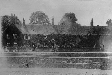
Bowers House from “The Music School” (Orchid Restaurant), c. 1920
BOWERS PARADE: Bowers House called Bowers 1533 PNH
BREADCROFT: Brederofte Close in 1598 PNH
*BRUTON LANE: The top part of Amenbury Lane. Leading to Hither, Middle and Further Bruton’s fields. *See Comment dated 10/12/2013
BURTON ROAD: Became part of Park Avenue North in 1925
*BYRON ROAD: Named after the celebrated poet. *See Comment below dated 05/07/2016
CARLTON ROAD: Named after Carlton-on-Trent, the home town of the developer. (Jane Meiklejohn to Simon A Cotton 1978)
CARPENDERS CLOSE: The Carpenters were an important yeoman family holding land at Kinsbourne Green from the 15th century. (HPH p.70-2)
CHURCH ROW: The west side of Church Green (see also Bachelors Row)
COLES LANE: Belgic trackway running from the Lea up Coles Lane/Dark Lane to the Ver near Redbournbury (HPH p15)
COOTERSEND LANE: John and Edith le Cotere 1272 PNH
*COWPER ROAD: Named after the celebrated poet. *See Comment below dated 05/07/2016
CRABTREE LANE: Edwin Grey’s book Cottage Life In a Hertfordshire Village explains how Crabtree Lane got its name. There used to be a pond at the entrance to Crabtree Lane with a large crab apple tree overhanging it. *From Comments below dated 04/06/2014 and 05/08/2014
CROFTWELL: Was to have been named Wellcroft after a local field but because of the risk of confusion with Dellcroft the order of the two was reversed.
CROSS LANE: Cross Farm Alexander de Cruce 1287 PNH
CROSS STREET (not ROAD): Name of road from Heath Road into heart of Bowling Alley, demolished in late 1950s.
CROSSWAY: in 1914 known as Cross Road in Kellys’ Directory
CROUCH LANE: otherwise known as Amenbury Lane
DEVONSHIRE ROAD: Name used on plan for the sale of St Nicholas estate 1897 for the road now known as Longcroft Avenue. Presumably dropped because of the ‘other’ DEVONSHIRE ROAD running between Station Road and Cornwall Road.
DOUGLAS ROAD: Named after the developer Douglas Willmott, a member of the an old Harpenden family who later moved to Westcliffe-on-Sea. (Colin Curl – Forum no 21)
FALCONERS FIELD: Faulkerner’s Farm from John Fawkener 1390
FALLOWS GREEN: Fellows Green 1840 Tithe Award
*FEMALE LANE: The lane passed Maples Cottages. *Appears to be Three Mile Lane, misheard. See Comment below dated 11/06/2013
FREEMANS LANE: See Amenbury Lane
GUESS’S LANE: Named after Mr Guess, farmer who left Roundwood in 1907. Was New Farm Lane before 1911. Re-named Roundwood Lane. (Geoff Woodward)
GILPIN GREEN: A happy choice for the extension to Cowper Road – see https://en.wikipedia.org/wiki/The_Diverting_History_of_John_Gilpin
*GLEMSFORD DRIVE: We do not know why. *See Comment below dated 28/05/2019
GRAFTON ROAD: Shown on the plan for the 1897 sale of the St Nicholas Estate as the name for the road parallel to – and above – Maple Road. Presumably named after the Duke of Grafton.
GRANBY AVENUE: The Marquis of Granby pub is at the bottom of Crabtree Lane.
GRANT GARDENS: Named after the after Cecil Grant the founder of St George’s School.
*GRASMERE AVENUE: Named after the Lake District location. *See Comment below dated 05/08/2014
GROVE ROAD: Named after The Grove, on the borders of Harpenden and Wheathampstead parishes – Richard ate Grove 1272 PNH
*GROVE AVENUE: As Grove Road. *See Comment below dated 27/01/2015
HALDEN LANE: Shown on Mansell’s field map of the Rothamsted Estate 1623. The road is described as leading from Harpenden to Harpenden Burye and shown as skirting Sawyers and Whitlocks fields. Original map is in Hertfordshire County Record Office (D/ELW P1) A copy by Ruth Haines appears on p 46 of New Men and a New Society (HPH). Route corresponds to Townsend Lane.
HAMMONDSEND: A Thomas Hamond appeared in the Assize Rolls for 1287 HPH
HARDING PARADE: Named after R.G.Harding, auctioneer (Authy: Ronald Gregory in ‘The Harpenden I Remember before 1914’ p.4), when 1 Arden Road was demolished and parade of shops built in 1963.
HATCHING GREEN: Was Hatchen End 1610 and was the home of John ate Hacche (PNH)
HAY LANE: see Amenbury Lane. The road above the cottages in Amenbury Lane is now called Hay Lane. *See Comment below dated 10/12/2013
*HEATH ROAD: Led to the Common from Southdown Road. *See Comment below dated 04/04/2017
*HICKLING WAY: See also Waveney Road, Martham Court, Wroxham Way, Oulton Rise and Barton Close. All presumably derived from the Norfolk and Suffolk Broads. *See Comments below dated 25/09/2020 and 30/12/2020
HOLCROFT ROAD: Holcroft Spring is Holcroft 1379 (spring is a copse in Middle English)
*HOLLY WALK: Apparently there have been no holly bushes here. *See Comments below dated 08/08/2017, 05/09/2017, and 28/05/2019
JAMESON ROAD: First appears on the map in 1898, three years after the Jameson Raid.
KIMPTON ROAD: Former name of Westfield Road (Authy: Plan of Westfield Estate, June 1904)
KINSBOURNE GREEN: Kenesberne 1201, probably ME berne from OE burial place hence Cyne’s burial place.
KIRKDALE ROAD: Built on the Kirk Wick (i.e. Church Field) adjacent to the house named Kirkwick, (later Gleneagle Hotel).
*LANGDALE AVENUE: A Lake District location. *See Comment below dated 05/08/2014
*LEA Road: Probably because of proximity to River Lea. *See Comment below dated 03/07/2013
LINDEN ROAD: Name shown on the plan for sale of St Nicholas Estate 1897 for the beginning of Park Avenue South
LONG BUFTLERS: Thought to be a mis-spelling of a field called Bustlers (the long S went out of use before 1810).
LONGFIELD ROAD: 1784 Named because of the shape of the field. HPH
LONGCROFT AVENUE : See Devonshire Road, which was the name given on the 1897 plan for the sale of the St Nicholas estate.
*MALLARD MEWS: Named after the local resident nesting Mallard duck. *See Comment from Geoff Woodward dated 05/03/2013
MANLAND: Was Mandilon in 1306, possible that this land provided the Maundy dole distributed to the poor on Maundy Thursday PNH
MAPLE ROAD: Named after Sir Blundell Maple, owner of Childwickbury and proprietor of Maples furniture business in Tottenham Court Road. (Forum no 21)
*MARTHAM COURT: See also Waveney Road, Hickling Way, Wroxham Way, Oulton Rise, and Barton Close. All presumably derived from the Norfolk and Suffolk Broads. *See Comments below dated 25/09/2020 and 30/12/2020
*MILTON ROAD: Named after the celebrated poet. *See Comment below dated 05/07/2016
MORETON END LANE: was Mutton End Lane (q.v.)
MUD LANE: see also Townsend Lane
MUD LANE: a track from Three Horseshoes pub, Bamville Farm on East Common to Ayres End Lane. Was Sears Lane, so-called because the farmer at Bamville Farm was John Sears, head of a well-known Harpenden family. His son John was Common Keeper for many years, and another son, William was a butcher in the village. (from Harpenden Free Press, 8 June 1951).
MUTTON END LANE: Original name of Moreton End Lane (q.v.) Appears in this form in 1750 Rental (Gover); and in auction particulars 10 July 1891
NEWCOME STREET: Original name for Park Hill, renamed in 1927.
*NOKE SHOT: the name of a long (strip) field on Pickford Common, probably containing an Oak tree, before it was developed as part of the Batford housing estate. *See Comment below dated 11/12/2012
NORTHFIELD ROAD: Le Northfield 1346 PNH
*OULTON RISE: See also Waveney Road, Hickling Way, Martham Court, Wroxham Way and Barton Close. All presumably derived from the Norfolk and Suffolk Broads. *See Comments below dated 25/09/2020 and 30/12/2020
OX LANE: Mentioned in the will of Thomas Nicholas of Harpenden 28 Dec 1598
PARK AVENUE: See Burton Road and Linden Road
PARK HILL: Originally Newcome Street (q.v.)
PARK LANE: Name given to Amenbury Lane on the plan for the sale of St Nicholas Estate in 1897
PARK MOUNT: Originally just the upper part of Symington Street (q.v.), but in 1938 the residents of Symington Street asked for the whole road to be called Park Mount (Geoff Woodward)
*PARK RISE: Links Park Hill and Park Mount. *See Comment below dated 26/03/2019
PHYSIC ROW: Name, probably nickname for Queen’s Road (q.v.) which consisted origially of six cottages belonging to Dr Kingston. (Edwin Gray, Cottage Life p.18)
PICKFORD: Pickford Mill is Molendin de Pykeford 1306 PNH. Pic means spur of land (HPH)
PIGGOTTS HILL: William Picot 1201
PIPERS AVENUE: Adam Pipard 1255 PNH
PORTERS HILL: Porter’s End from Richard Porter 1342 PNH
PROVIDENCE PLACE: Part of Walkers Road on the Southdown triangle – see pre 1930 Map and Guide issued by Golby, auctioneers and estate agents.
QUEENS ROAD: Originally known as Physic Row (q.v.) *See Comment below dated 23/05/2013
ROTHAMSTED: Rochehamested 1210 Rook-frequented homestead PNH
*ROUNDFIELD AVENUE: John Olley tells us that there was a round or oval field nearby. *See Comment below dated 17/02/2018
ROUNDWOOD LANE: Originally Guess’s Lane(q.v.)
SAUNCEY AVENUE: On 1913 map called Manland Avenue.
Sauncy Wood is Saunsette 1333 PNH
*ST ANDREWS AVENUE: An auction on 29.05.1901 included one house in Kirkwick Avenue called St Andrews. *See Comment below dated 24/04/2012
*SHAKESPEARE ROAD: Named after the celebrated poet and dramatist. *See Comment below dated 05/07/2016
SHEPHERDS WAY: The Shepherds feature in records from 1634 onwards. (Story of Harpenden p.10)
SIBLEY AVENUE: There are references to Sibleys at least as early as 1623 (HPH Appx3 vii)
SOUTHDOWN ROAD: was WHEATHAMPSTEAD ROAD until 1923.
STACKHOUSE LANE: c. 1840 – location?
STAKERS LANE: See Station Road. Henry Staker was a brickmaker in 1724 (HPH p.172). It seems that Staker’s Lane, unlike Station Road, ran up the track behind Carlton Bank, because the sale of the Carlton Bank properties described them as being between Station Road and Stakers Lane. (Authy: Cornelia Clutterbuck 30.11.86)
*SPENCER ROAD: Named after the celebrated poet. *See Comment below dated 05/07/2016
STATION ROAD: Formerly Stakers Lane. Renamed Station Road in 1892
STEWART ROAD: Sir Halley Stewart lived in the Red House at the end of the road. He offered his house to Harpenden in 1938. (Story of Harpenden p.321)
STREET LANE – location?
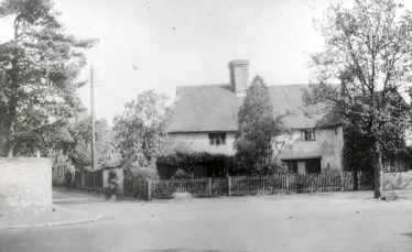
Sun Lane, before widening, c.1920
SUN LANE: So described in 1747. The pub ‘The Sun’, now the Red Cow did not come until 1799. (Amy Coburn). Also evidence for the Sun pub at the corner of Sun Lane and High Street from about 1637; owned by Hawkins family in the 1780s, and closed either in about 1800 or 1877 (Geoff Woodward). The adjacent cottage was demolished in 1931 when Sun Lane was widened.
SYMINGTON STREET: In response to a petition from residence in the road the Council agreed that the street should be incorporated with Park Mount. (Herts Advertiser 16.09.38)
TALLENTS CRESCENT: Tallent’s Farm – Richard Tarant 1294 PNH
*TENNYSON ROAD: Named after the celebrated poet. *See Comment below dated 05/07/2016
THOMPSONS CLOSE: Once known as Vinegar Lane (q.v.)
TOPSTREET WAY: Topstreet Farm was Toppystret in 1436 PNH
TOWNSEND LANE: Townsend Lane was usually known as Mud Lane (Miss K Warington’s entry in the “I Remember” competition 1979.) See Halden Lane
TYLERS: “Named after our building manager” (E. Perrott of Royce in a letter to Simon Cotton 31.03.78)
VAUGHAN ROAD: 1859 Edward Thomas Vaughan was the first Rector of Harpenden.
VINEGAR LANE: Nickname for Thompson’s Close. There are various explanations: a) smell from the brewery in Lower High Street; b) character of the shopkeeper at the general store.
WALKERS ROAD: Mr Walker had a straw plait factory at Gorselands (Edwin Grey – Cottage Life p.1). Referred to as SMITHY LANE in 1909 on sewer-pipe plan
*WAVENEY ROAD: See also Hickling Way, Martham Court, Wroxham Way, Oulton Rise, Barton Close. All presumably derived from the Norfolk and Suffolk Broads. *See Comments below dated 25/09/2020 and 30/12/2020
WELLCROFT: Was changed to CROFTWELL in 1962 in order to avoid confusion with DELLCROFT
*WELLS CLOSE – built on the site of Ridge House in the 1960s by Leonard Green. He wasn’t sure what to call the development and suggested his staff put their names in a hat and he would pick one out. Barbara Wells, a secretary at the firm, had her name pulled out, hence “Wells Close”. *See Comment below dated 22/01/2018
*WEYBOURNE CLOSE: We do not know, *See Comment below dated 28/05/2019
WESTFIELD ROAD: At one time known as Kimpton Road (q.v.) Westfield 1390 PNH. It was the westernmost of Westminster Abbey’s open fields in the Lea valley, even though it is in the north-east corner of Harpenden parish. (HPH)
WHEATHAMPSTEAD ROAD: became Southdown Road in 1923
WILLOUGHBY ROAD: The name of a curate at All Saints Church, Coldharbour Lane, who died ‘rather suddenly’ in 1919 (C.W.Curl Forum no.21)
WINDMILL LANE: Former name (unofficial?) of Thrales End Lane where there was a windmill. (Flora Humm 22.11.87)
WOODEND LANE: Woodend Farm was probably the home of Robert Ate Wode 1390 PNH
*WORDSWORTH ROAD: Named after the celebrated poet. *See Comment below dated 05/07/2016
*WROXHAM WAY: See also Waveney Road, Hickling Way, Martham Court, Oulton Rise, Barton Close. All presumably derived from the Norfolk and Suffolk Broads. *See Comments below dated 25/09/2020 and 30/12/2020
Compiled by Simon Cotton 1980s – with later additions and corrections.
Comments about this page
Dr Beeching was my great uncle Richard. He was hired by the Government in 1961 from ICI in the private sector, to review the loss-making British railway system. He produced two detailed analytical reports (1963 and 1965) largely saying that 80% of the customers travelled on less than 5% of the system. The Harold Wilson Labour Government of 1964 accepted the reports and ordered British Rail to implement network reductions; it suited the politicians to blame the closures on an outsider from the private sector. Richard did what he was asked to do – produce an independent report; no more. He returned to ICI in 1965.
The developer/building company that built all the houses around Wroxham Way and others had a registered address in Norfolk so I am assuming this is why they have a Norfolk and Suffolk theme
Balfour Court – near Waveney Road – was named after Balfour-Beatty (the developer who built it, ca. 1989-1992) and NOT the politician.
Ed: See Comment about Waveney Road from Liz above. We will add this to the list – thank you.
My daughter has a local history project to complete for brownies and we are not having much luck in finding out information. Does anyone know why Waveney Road was given this name and what was there before the houses were built?
Thank you!
Ed: Waveney Road, together with Hickling Way and Martham Court, was built on the site of Harpenden East Railway Station. We suggest that you type this into the search box – there are over a dozen pages with reference to the Station, so perhaps you would like to view them and point your young daughter towards the most relevant.
All these roads share their names with places on the Norfolk and Suffolk Broads, together with one off Manland Way and two off Ox Lane. They are in Suffolk: Waveney Road (River), and Oulton Rise (Broad), and in Norfolk: Hickling Way (Broad), Martham Court (Broad). Wroxham Way (Broad and town), and Barton Close (Broad). The two off Ox Lane were built on the site of Ox Lane Nursery Garden. The search box will take you to these – the page by Geoff Woodward has a good aerial photo and map.
We don’t know why these place names were chosen – perhaps the developer loved Norfolk and Suffolk and enjoyed exploring and sailing these lovely rivers and broads.(see Andrew’s comment above-Ed.)
We hope you and your daughter enjoy searching the site.
Best wishes from the Website team.
Does anyone know how Weybourne Close got its name? The Wyborn:Weybournes came from Kent and I am curious as to how the name reached Harpenden.
Ed. The Urban District Council Minute books merely record that the General Purposes Committee, on 20 September 1938, that ‘formal notices having been received, no objection has been raised to streets (off Crabtree Lane) being names as follows: Glemsford Drive, Weybourne Close and Holly Walk’. None had a particular local association – though there may have been holly bushes nearby.
I was born in Harpenden in 1941 at the hospital on Luton Road nearly opposite the old cinema, & lived there at Park Rise until 1972 when I got married. Park Rise is not listed in your street names, but presumably is derived from Park Hill & Park Mount.
Roundwood Halt was the nearby station until closure. In the mornings, I used the 7.00 am freight train to Hemel as my alarm clock.
Ed. Park Rise was developed from 1927 onwards, and links Park Hill and Park Mount. We will go through the list of names, and aim to add dates for when roads first appeared or when they changed their names.
My first home was in Meadway from baby to two years old; then moved to 36 Sibley Avenue until February 1969 when we moved away to live in Barnstaple, Devon. Continued to visit for many years and have many fond memories. Parents are called David & Doreen Bispham (maiden name Tucker) with years of Harpenden history.
No mention of Roundfield Avenue. Was it on the site of a round field or is there another reasons for its name? I lived there as a child and my parents still do.
Ed – apologies for our delay in publishing this. According to resident John Olley, there was a round/oval field stretching from Lower Luton Road (parallel with South View Road), where he remembers helping with hay-making as a child in the 1940s.
Pamela Lawrence has provided information about how Wells Close (on the site of Ridge House which burned down in the 1960s), got its name. She wrote: “The houses on Wells Close were built by Leonard Green who was a client of the firm I worked for in the 1960s. He wasn’t sure what to call the development and suggested we (staff members) put their names in a hat and he would pick one out. My dear friend Barbara Wells, a secretary at the firm, had her name pulled out, hence ‘Wells Close'”.
No, there was no holly bush, or bushes at all in Holly Walk.
Any one know how Holly Walk got its name? My home and my mother’s home till her death in 2015.
Ed. Sorry, we don’t know. Was there a prominent holly bush?
I have been looking for pictures of Heath Road around 1940. My husband’s grandparents lived at number 1, and he has happy memories of visiting them, and of their chickens kept on the line bank! Their name was Bradbury. Would so appreciate any help.
Ed: although we have no close-up pictures of Heath Road, we did find a number of photos to illustrate John Reeks memories, though views down the road seem mostly to date after the cottages in Southdown Road and the corner of Heath Road were demolished because of persistent flooding before the whole area was re-developed.
Cowper Road not listed…. Lived there in 1950s. Brother born in Harpenden.
Ed: This list started with names which have local or historical origins. During the 1880s new roads were named after poets: Milton, Shakespeare, Spenser – and Cowper – with another set off Sun Lane: Tennyson, Wordsworth, Byron.
My great grandfather Arthur Tuffin lived in Back Lane Coldharbour.
Grove Avenue is not listed. I lived there for 16 years from 1949 until 1965 and the house was sold in 1977 after my father’s death. Some houses were pre-war and after the war council houses were built above No 29 and these lead to a new estate built in the 1960s I think.
Ed: See Grove Road for the origin of the name.
‘Bachelors Row’ or ‘Batchelor’s row’ (photo) ?
Pretty obvious where ‘Langdale Avenue’ and ‘Grasmere Avenue’ come from! Though I do have to admit that even after years of visits the ‘Lakes’ it is only recently that the connection dawned on me! I suppose walking along them every day in my childhood registered them to me as just road names.
I lived in ‘Glemsford Drive’ (Glemsford in Essex?) just off ‘Crabtree Lane’ which really did have Crab Apple trees growing in the vicinity in the 1940s.
Ed. It is most commonly Batchelors Row but we don’t know why.
Geoff Woodward tells me that Mallard Mews was so named because for many years a mallard nested in the garden area by Jarvis’s office at 212 Station Road, and successfully raised chicks which then had to be led across Station Road to the river. I do remember the traffic having to stop to let them cross but hadn’t connected the name of the close with that particular duck.
Yet another name for Amenbury Lane. In the 1871 census it is called Hales Lane (was this Hay’s Lane mis-heard or mis-transcribed or vice versa perhaps?).
From information supplied by Rothamsted’s archivist (copy hold) and John Wassell (tithe awards)Bruton’s Lane presumably comes from the names of fields abutting the lane i.e Hither, Middle and Further Bruton fields and as these fields abut onto both legs of Amenbury Lane presumably it may not have been just the upper part that was called Brutons. In fact since Further Bruton’s was also called Back Lane field the upper part was possibly known as Back Lane.
Unfortunately there was also a Back Lane at Coldharbour (1861 census) near the GNR station or was that what is now Ox Lane?
‘Female Lane’ only appears on the Dury & Andrews map of 1766 and appears to be ‘Three Mile Lane’ both misheard and misplaced. It is placed over a dotted line on the map which is actually the parish boundary – also misplaced! For more details see my article on Female Lane in the Society’s Newsletter 103, page 20.
Edwin Grey’s book Cottage Life In a Hertfordshire Village explains how Crabtree Lane got its name . There used to be a pond at the entrance to Crabtree Lane with a large crabapple tree overhanging it.
Kirkdale Road, where I lived for about 20 years or more in the 1940s, 50s and 60s is not listed. Why not?
ed. A house called “Kirkwick” was built in the NE corner of the Kirk Wick (i.e. Church Field), bounded by Luton Road and Townsend Lane. Subsequently this house expanded to become the Gleneagle Hotel.
Kirkdale was chosen as the name for the road later developed south of “Kirkwick”.
The original list of road names drawn up by Simon Cotton concentrated on older roads. We are always pleased to consider derivations submitted for any roads so far un-listed.
I have very fond memories of Harpenden from the 1950’s and early 1960’s. When very young I stayed with my uncle and aunt somewhere on West Common I think (Myrtle Cottage). This was subsequently bought (again I think) under compulsory purchase when they bought a house in Aley Green (Sunniside). Coming from the north of England I thought I had come to a place called heaven. Does anyone know of a map that would actually have the cottage on it? I am unsure which road it would have been on, but I know we used to walk the dogs across the common with the lights of Harpenden main street in the distance. Congratulations on such an interesting site.
Ed We apologise for taking over two months to find the answer to this query, which can be found in a page on Myrtle Cottage. We enjoyed tracking this to Queen’s Road on the eastern side of Harpenden Common.
I spent my childhood in Batford. From 1954 onwards we lived at the junction of Porters Hill and Noke Shot. I have often wondered about the origin of the name Noke Shot, can anybody help with this?
ed. We have made an entry for Noke Shot in the main list – a ‘shot’ was a long field, typically in a former mediaeval open field.
I was born in Lea Road in 1939, presumably this is a connection to the River Lea.
Ed: Yes, probably, but can anyone confirm this?
I have an odd little snippet on the origin of St Andrews Avenue. My father James Gordon Logan was born on 20.01.1918 in “St Andrews” which his birth certificate says was in Longcroft Avenue not Kirkwick. The house either belonged to or was lent to the Egypt General Mission of which at the time my grandfather John Gordon Logan was Secretary. Shortly afterwards they moved to Highbury and I have no further information on what happened to “St Andrews”. I wish I had!
Add a comment about this page